- Follow us:
- Our Commodities:
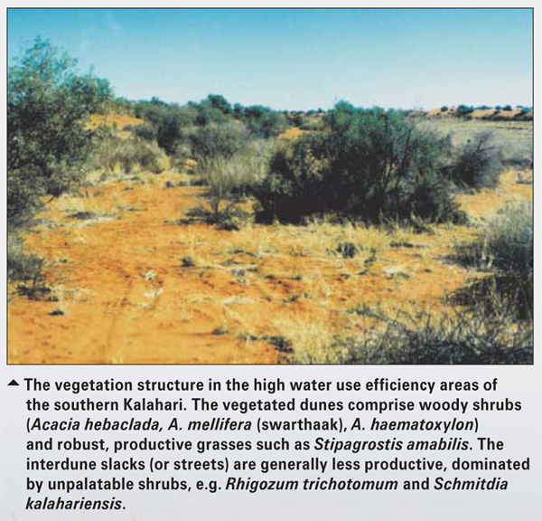
-
November 2015
TONY PALMER, specialist research: ARC-Animal Production Institute, Grahamstown
Water use efficiency is one of several unifying concepts for comparing different rangeland condition classes and land use options. Throughout Southern Africa there are examples of places that are perceived to be degraded due to the application of incorrect farming practices including overgrazing and incorrect ploughing.
With increasing levels of atmospheric CO2, there is an urgency to improve the efficiency of getting CO2 out of the atmosphere, and to understand under what land use conditions we are achieving increased efficiency of CO2 uptake.
In over-grazed rangelands, the predominance of short green grass does not necessarily mean that an ecosystem is less efficient, as the high numbers of livestock may simply be eating the grass production immediately after it has grown. It is therefore important to develop indices that reflect the functionality of the ecosystem before we pronounce on the desirability of one or other vegetation state.
Water use efficiency has been developed over many years in the irrigation sector, but has seldom been applied to producers in the dryland cultivation and rangeland/grazing community. The concept essentially embodies the amount of water that it is necessary for a plant to evaporate in order to capture carbon.
In order for plants to capture CO2 from the atmosphere, they must open their stomata, and that results in water loss.
It is therefore essential that plants control water loss by opening the stomata for just long enough to effect carbon dioxide uptake. If the plant leaves its stomata open for too long, it can lose too much water through evapotranspiration and become desiccated.
Similarly, if the stomata are closed too much in the wet season, then the opportunity to capture CO2 is lost, and the plant starves.
Thus, achieving a balance between water loss and CO2 uptake is crucial to the success of crops and veld grasses. Although there are several forms of the water use efficiency index, for our purposes we define it as the weight of dry matter (kg) collected per mm of evapotranspiration (kg DM/ha/mm/year).
This also needs to be defined on an area basis (in this case hectares) and time (year). It has been suggested that lower than expected water use efficiency may reflect landscape-scale degradation or disfunctionality of a landscape.
It also provides for an assessment of the efficiency of dryland production for rainfed agriculture.
Once of the most cost effective ways of assessing water use efficiency is to use satellite imagery to build models that accurately reflect the production and water use of the vegetation. Recent advances in the preparation of moderate resolution (1 km) (e.g. from the MODIS programme) estimates of net above-ground primary production (NPP) have made it possible to more confidently predict plant production.
These models are based on the premises that the energy from the sun that drives photosynthesis is captured by the plants, and only that which is not utilised is reflected back to the orbiting satellite.
The sensors on the satellite record only the amount of energy reflected by the earth’s surface, called the fraction of photosynthetically active radiation (fPAR). This basic principle involves some well-researched equations from physics and enables us to produce a weekly picture of the net primary production of the entire earth.
Similarly, it is possible to model actual evapotranspiration using a combination of satellite imagery and weather station data from the 7 000 weather stations that are run by the World Meteorological Network. Using some standard formulae, we can convert the net primary production into dry matter production as plants have a remarkably universal ratio of carbon to dry matter (0,42 g C/g DM) and evapotranspiration (ET) have enabled the preparation water use efficiency surfaces for southern Africa from 2000 - 2014.
Using earth observation products from the MODIS programme (MOD 17 [NPP] and ET MOD16), we prepared annual water use efficiency surfaces for southern Africa, where water use efficiency = NPP/ET.
We had previously evaluated the quality of the MODIS NPP product using ground surveys of annual biomass production at five sites. To build confidence in these models of production derived from earth observation, we collected above-ground production data for transects in the succulent Karoo, the semi-arid savannah in the southern Kalahari, the dwarf shrublands of the Nama-Karoo and the grasslands of the north Eastern Cape and KwaZulu-Natal.
We compared our ground-based measurements with those predicted by the remote sensing models and were very comfortable that the values accurately reflected those measured on the ground. We also assessed the accuracy of the MODIS ET product using data from the eddy covariance flux tower located at Skukuza in the Kruger National Park.
This tower has been measuring atmospheric CO2 and water fluxes for over 14 years, and represents an excellent record of the amount of water used by the savannah vegetation of the Mpumalanga Lowveld.
These assessments indicated that we could use both of these products as a reliable reflection of primary production and evapotranspiration across a range of vegetation types in Southern Africa. Water use efficiency was calculated using these annual NPP and ET products for each year from 2000 until 2013 and this is the first product of this nature for South Africa.
This data, one of which is presented here as an image, provide the first national database that can be used to evaluate the impact of contrasting land cover types and land use strategies on water use efficiency. The range of water use efficiency values that have been calculated for the region are directly comparable to those derived from the ratio of DM production to rainfall which has been applied in other studies.
There is an inherent stability across Southern Africa, although 14 years of data may not be enough to detect significant trends.
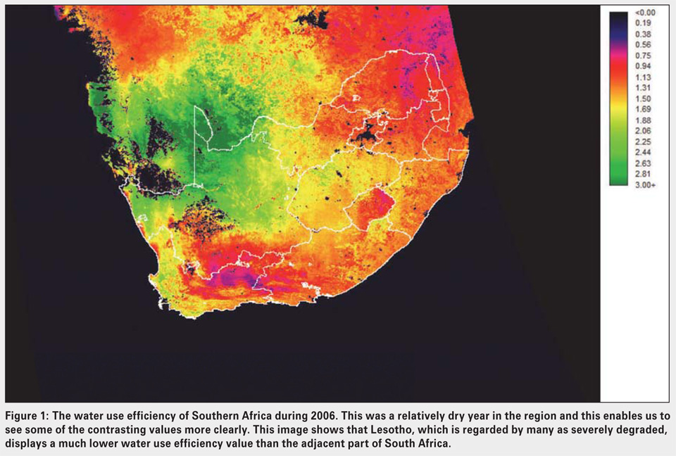
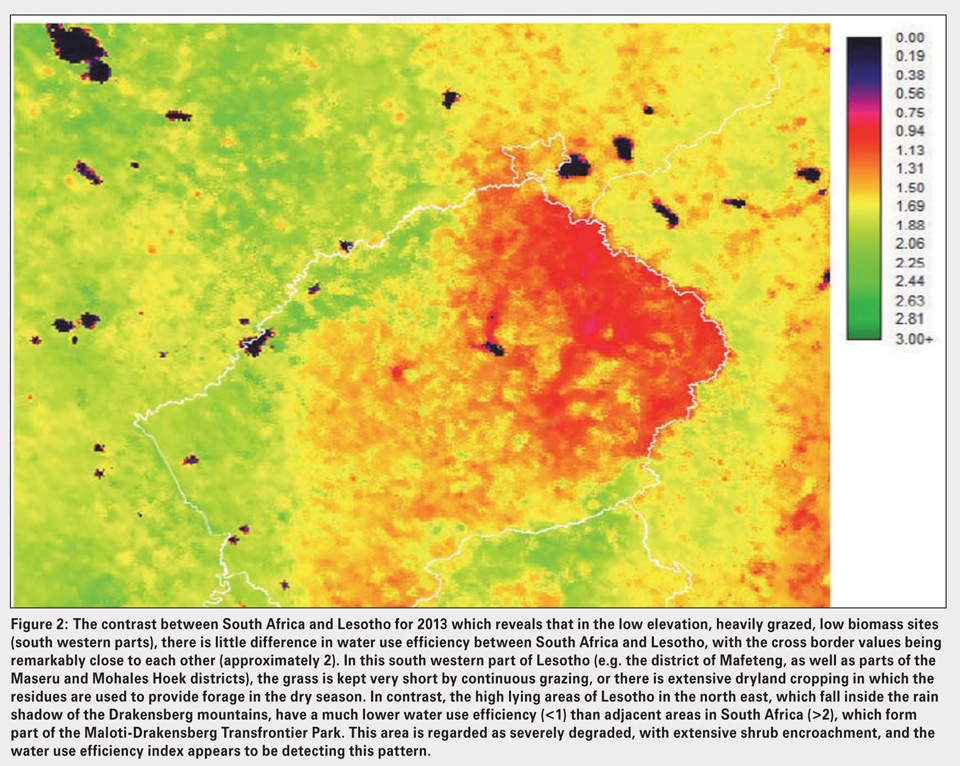
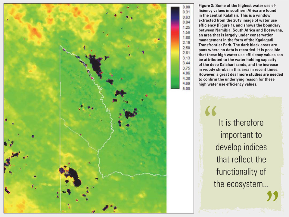
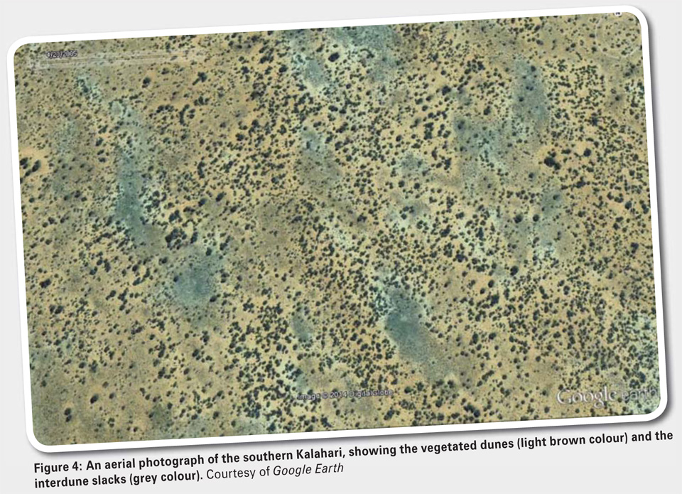
 The water use efficiency maps presented in Figure 1 to Figure 4, and the interpretation of the patterns, represents a first attempt to understand the significance of the application of this concept to optimise land management in Southern Africa.
From this initial analysis, it is clear that not all of the patterns are obvious, and a lot more effort has to go into interpretation to improve our understanding and to identify those land use options that have the best water use efficiency. The Succulent Karoo biome, particularly the Little Karoo, has some of the lowest water use efficiency values.
This may be linked to the prevalence of leaf and stem succulent plants which tend to use the CAM photosynthetic pathway. In addition, low values are also associated with the semi-arid savannah of the Limpopo province, where woody encroachment is a serious veld management issue. The maize growing areas of the Free State and southern Mpumalanga have moderately high water use efficiency values, suggesting that these regions are performing well in their CO2/water functionality.
![]() For more information, contact the author at palmert@arc.agric.za.
For more information, contact the author at palmert@arc.agric.za.
Publication: November 2015
Section: Focus on