- Follow us:
- Our Commodities:
-
August 2022
| RICHARD MCPHERSON, AGRIBUSINESS AND PROJECT MANAGEMENT CONSULTANT |
 |
Soil conservation work means any work which is constructed for the prevention of soil erosion, as well as the improvement of the vegetation or surface of the soil. It also includes work to improve the drainage of superfluous surface or subterranean water, reclamation of any water resource, and the prevention of the silting of dams and pollution of any water resources.
Some of the most important and precious resources to be managed in the agriculture of a country are its soils and water resources. The responsibilities of landowners are largely covered in the National Water Act (No. 36 of 1998) and the Conservation of Agricultural Resources Act (No. 43 of 1983), which addresses soil conservation amongst other facets relating to agriculture.
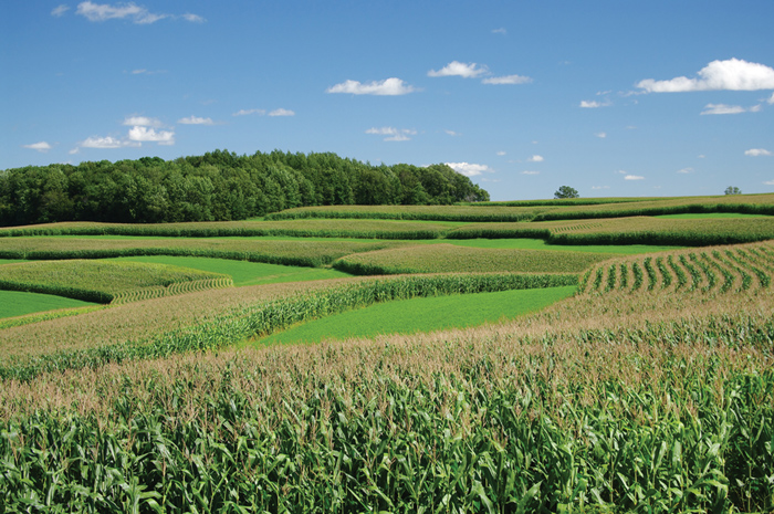
Grain farmers spend much time in tilling and preparing soils in the varying topology and climatic zones of South Africa for grain production. The soils, depending on the tillage practices of each individual, are thus exposed to the differing rainfall patterns in which heavy downpours or light continuous rains effect the soil. Heavy downpours can remove most of the highly productive topsoil if the resource is not protected.
DO AN ASSESSMENT
Most farms in South Africa have had some planning done regarding the building of farm dams, grassed waterways, and the laying out and building of contour banks from tilled lands to either planned constructed or natural waterways.
Unfortunately, the building of contours in the late 1950s and 1960s was based on an incorrect formula in which the starting high-side point of the contours started with a fall, which then was reduced at varying intervals.
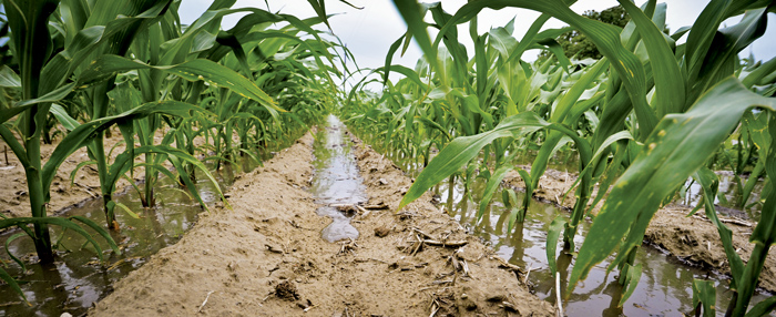
This resulted in silting of the contour at about halfway and enormous damage, as the contours in heavy rains broke halfway and resulted in enormous damage and loss of soil when each lower contour broke in turn. This can be seen throughout South Africa. The only solution is to flatten them and recontour the whole land correctly at great cost; or grass the whole length of the contours into the planned or natural waterway. Larger stormwater contours can be built at intervals to reduce the impact on poorly planned areas. Grassed waterways should be checked and repaired as soon as possible if erosion gullies start developing.
Various scale maps available from the surveyor general for your farming area can assist with the planning, as well as looking at particular lands with Google Earth. Detailed aerial photos of your farm can also be obtained from the surveyor general’s office. These show all the faults and help with detailed planning.
The design and the spacing between contours are of great importance to safely discharge the runoff and to limit soil erosion.
WATER RUN-OFF
The function of the contours is to remove any run-off at a constant rate from a whole land into a grassed or natural waterway, so that no damage or soil erosion can occur. Run-off rates depend on soil types and the slope of the land. Sandy soil has a high permeability, with clay having the lowest. Once the soil profile has absorbed enough water, it starts to flow down and across the lower side to the natural waterways.
Conservation tillage in crops, together with cover crop rotations, will do much to reduce excess run-off. Planning must include provision for run-off, which will occur from any saturated soil profile that receives more rain.
Any areas not being farmed for crops should be put to an appropriate grass type for your area to reduce any potential erosion.
Guidelines
Working contours are laid out considering the slope of the land topography, soil types and potential water run-off rates. A continuously sloped contour of one in 300 has since the early 1960s been proved to work very effectively in all soil types. This means that for every 300 m of contour, it will drop one metre from the high to the low side.
The key planning for the level between contours is an art as well as a science. The interval between contours in a land of a very high slope can result in so many contours that it becomes impractical to farm. Intervals of 1,2 m are a useful starting point. Correctly designed contours should be extended into natural waterways.
A dumpy level that can focus on the measuring staff height indicator a kilometre away is useful. Two people, each with a staff and rope of 30 m between them, can identify the points while laying out the contours. The fall between points for a 30 m rope interval would thus be 0,1 m if the contours were to be made at the ideal one-in-300 slope. Once the points are established, closer inspection can indicate a fair line or curve to be followed when contour construction begins. Always write down the level for each point taken.
Contours can be made with graders, mouldboard ploughs, angled discs and properly designed double-gang disc implements.
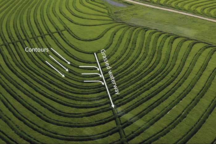
Elements of a contour bank system.
GOLDEN RULES
Legally you have to provide your neighbours with the run-off water at the lowest point on your farm. You must build waterways at adjoining property lines to enable your run-off to reach the other owner’s property at your lowest point, unless it is possible to plan a larger area with several owners co-ordinating the planning works for the catchment area for dams, contour and waterways. These agreements should be covered legally in case new future owners object to the previous planning implemented.

Publication: August 2022
Section: Pula/Imvula