November 2014
36
GARRYPATERSON,
ARC-Institute for Soil, Climate andWater
FOCUS
Natural resources andenergy
Special
Natural resource assessments for
agricultural planninganddevelopment
A
griculture restson threepillarswherenatural resources are
concerned. These are the soil (comprising the growthme-
dium for theplant), theclimateconditions (whichsupply the
plant with sufficient water and heat) and the terrain (ena-
bling the crop tobe physically planted, to grow and tobe harvested
sustainably).
SouthAfrica has almost 12million hectares ofmoderate to high po-
tential soils, which comprises 10,3% of the country. However, when
suitable climatic conditions are added to the soil factors, this figure
falls to just over 2 million hectares, or around 1,8%. This indicates
perfectly the limited amount of productive land in South Africa, as
well as theneed topreserve and sustainably utilise this land.
The first step in sustainable natural resourcemanagement is ensur-
ing that the land will support a specific land use practice over the
long term. For example, only the better agricultural land in South
Africa will support grain production, while more marginal agricul-
tural landwill support forage andpasture-basedproduction.
For this reason, agricultural development shouldonlyoccur in areas
where thenatural resourceswill support theagriculturalpractice.The
only way to ensure that this occurs is to understand the resources
that are available. Natural resource assessments (surveys and inter-
pretations) are the key tounderstanding the resources.
For example, asoil survey isan inventoryof thepropertiesof thesoil
(suchas texture, internal drainage, parentmaterial, depth toground-
water, topography, degree of erosion, stoniness, pH, and salinity)
and their spatial distribution across a landscape. Similar soils are
grouped intodefinedmapunits and their boundaries are delineated
on amap.
Eachmapunit hasauniqueset of physical, chemical andmineralogi-
cal characteristicsandhassimilar reactions touseandmanagement.
The informationassembled ina soil surveycanbeused topredict or
estimate the potentials and limitations of the soils’ behaviour under
different uses.Assuch, soil surveyscanbeused toplan thedevelop-
ment of new landsor toevaluate theconversionof land tonewuses.
Soil surveys also provide insight into the kind and intensity of land
management that will beneeded.
The concept of land capability combines the three natural resource
elements or factors listed above (soil, climate and terrain) and uses
set parameters to determine a specific class for a given area. The
basis of the land capability assessment in South Africa is the well-
known Land Type Survey, which is a coun-
try-wide inventory of natural resources, i.e.
soil pattern, macroclimate and terrain type,
carried out between 1972 and 2002 by the
ARC-Institute for Soil, Climate andWater.
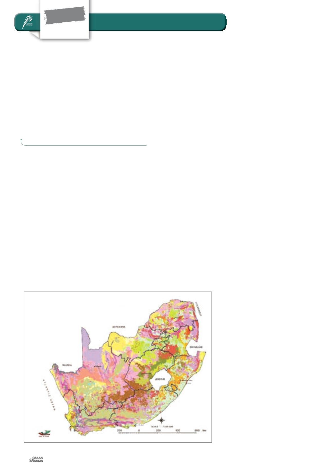
Thevarietyof soilsoccurring inSouthAfrica
can clearly be seen on the map which was
developed using the Land Type informa-
tion and displaying the broad soil patterns
of South Africa, including coastal sands,
swelling clays, plinthic soils, duplex soils,
rocky soils, wetlands and many others (see
Figure 1
).
From the Land Typemap, each of the 7 071
unique land type map units is allocated to
one of eight land capability classes. These
classes are basedon the original USDA land
capability system, whereby Classes I and II
comprise areas with little or no limitations
to rainfed agriculture, Classes III and IV
comprise those areas which are still con-
sidered arable, but withmoderate to severe
restrictions.
Classes V to VIII comprise non-arable land
with increasingly serious restrictions, ei-
ther in terms of restricted soil, steep terrain,
Figure 1: Broad soil patternmap from LandTypeSurvey information.
Copyright: ARC-ISCW


