- Follow us:
- Our Commodities:
-
November 2014
GARRY PATERSON, ARC-Institute for Soil, Climate and Water
Agriculture rests on three pillars where natural resources are concerned. These are the soil (comprising the growth medium for the plant), the climate conditions (which supply the plant with sufficient water and heat) and the terrain (enabling the crop to be physically planted, to grow and to be harvested sustainably).
South Africa has almost 12 million hectares of moderate to high potential soils, which comprises 10,3% of the country. However, when suitable climatic conditions are added to the soil factors, this figure falls to just over 2 million hectares, or around 1,8%. This indicates perfectly the limited amount of productive land in South Africa, as well as the need to preserve and sustainably utilise this land.
The first step in sustainable natural resource management is ensuring that the land will support a specific land use practice over the long term. For example, only the better agricultural land in South Africa will support grain production, while more marginal agricultural land will support forage and pasture-based production.
For this reason, agricultural development should only occur in areas where the natural resources will support the agricultural practice. The only way to ensure that this occurs is to understand the resources that are available. Natural resource assessments (surveys and interpretations) are the key to understanding the resources.
For example, a soil survey is an inventory of the properties of the soil (such as texture, internal drainage, parent material, depth to groundwater, topography, degree of erosion, stoniness, pH, and salinity) and their spatial distribution across a landscape. Similar soils are grouped into defined map units and their boundaries are delineated on a map.
Each map unit has a unique set of physical, chemical and mineralogical characteristics and has similar reactions to use and management. The information assembled in a soil survey can be used to predict or estimate the potentials and limitations of the soils’ behaviour under different uses. As such, soil surveys can be used to plan the development of new lands or to evaluate the conversion of land to new uses. Soil surveys also provide insight into the kind and intensity of land management that will be needed.
The concept of land capability combines the three natural resource elements or factors listed above (soil, climate and terrain) and uses set parameters to determine a specific class for a given area. The basis of the land capability assessment in South Africa is the well-known Land Type Survey, which is a country-wide inventory of natural resources, i.e. soil pattern, macroclimate and terrain type, carried out between 1972 and 2002 by the ARC-Institute for Soil, Climate and Water.
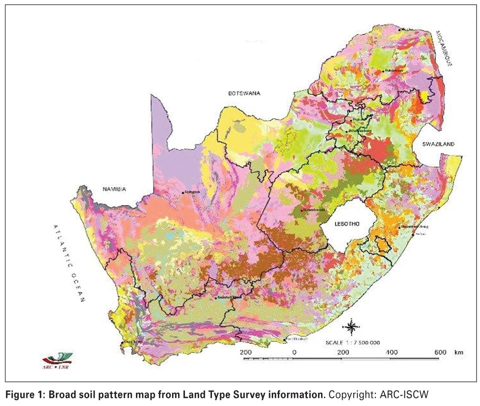 The variety of soils occurring in South Africa can clearly be seen on the map which was developed using the Land Type information and displaying the broad soil patterns of South Africa, including coastal sands, swelling clays, plinthic soils, duplex soils, rocky soils, wetlands and many others (see Figure 1).
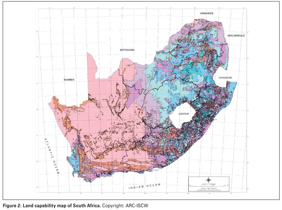
From the Land Type map, each of the 7 071 unique land type map units is allocated to one of eight land capability classes. These classes are based on the original USDA land capability system, whereby Classes I and II comprise areas with little or no limitations to rainfed agriculture, Classes III and IV comprise those areas which are still considered arable, but with moderate to severe restrictions.
Classes V to VIII comprise non-arable land with increasingly serious restrictions, either in terms of restricted soil, steep terrain, rockiness and/or an unfavourable climatic regime. Once the parameters are applied to the land type units, the dominant land capability class of each can be established and the results are shown in the map below (Schoeman et al., 2002).
The blue areas on the map represent the “better” classes of land capability (Class I to IV), while the pink and purple areas represent the rest (Classes V to VIII) (see Figure 2).
Recently the ARC-ISCW has carried out a series of projects for a range of clients where the basic land capability assessment has been taken one step further, namely to adjust or match the parameters being assessed for a range of specific crops and their requirements.
This information was obtained from available literature from the existing knowledge and experience of the ARC-ISCW survey staff, as well as a range of crop specialists as and when required. For each crop, an algorithm (a mathematical set of “instructions”) was created and the parameters applied to the land type data.
In other words, the land qualities were matched with the crop requirements to assess the crop suitability of each land type. The results were studied and compared with actual experience and empirical crop yields where necessary, so that eventually the best possible result and most reliable map could be obtained for each crop.
Most of these algorithms were created for rainfed crop cultivation, so that the required rainfall, temperature, frost-free season, as specific to each crop, had to be determined. However, for a number of crops in specific areas that grow especially well under irrigation, the climatic factors were omitted, leaving only the soil and terrain factors, with the assumption that most, if not all of the required crop moisture would be supplied by irrigation.
This is especially relevant in the light of the fact that although only around 10% of the cultivated area in South Africa is under irrigation, it produces around 30% of the gross value of the country’s crop production (Scotney & Van der Merwe, 1995), and around 90% of the fruit, wine and most vegetables (Nieuwoudt et al., 2004).
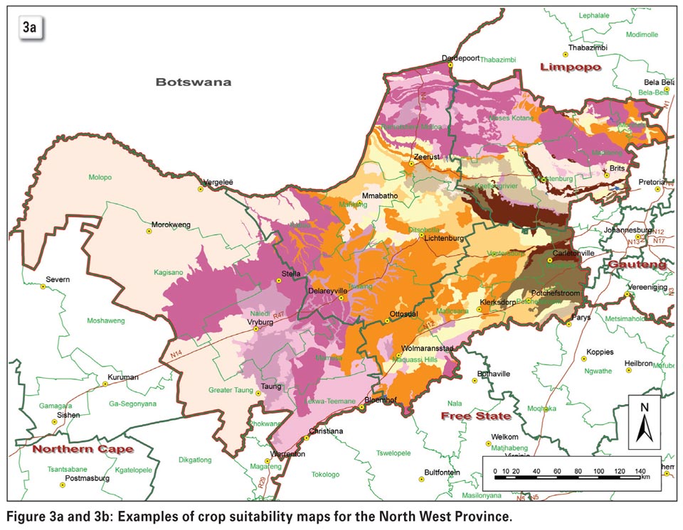
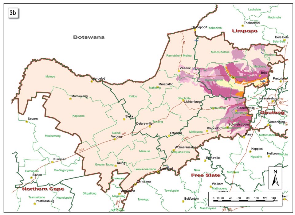
The results of two of the crop suitability maps can be seen in Figure 3, where the potential for rainfed maize (a) and rainfed soya (b) in the North West Province is shown. The results generated from these algorithms provide:
The limitations due to the scale of the baseline information must be taken into account, as well as the fact that cultivars and other production practices are constantly evolving and improving. Smallscale, reconnaissance or general natural resource surveys, such as the Land Type Survey, only give a broad picture of the dominant types and distribution of soil, climate and terrain that occur over relatively large areas.
The landscape may actually include fairly significant areas of different soils that are not identified on the map, due to scale. As such, reconnaissance surveys are best suited to making general comparisons of land capabilities and limitations on a district and national scale. They are not reliable for making on-farm decisions as they lack the detail necessary to describe the variation in the soil types on the farm. When detailed soil survey data is needed, but unavailable, on-site investigations are necessary. On-farm soil surveys can be designed for a specific purpose or a general purpose.
However, the fact that South Africa has a national, geo-referenced and reliable source of baseline natural resources data can only be advantageous.
These products can be utilised for the planning of grain production, both for commercial and emerging farmers, for specific regions as well as for the country as a whole.
For further information, contact Dr Garry Paterson at garry@arc.agric.za.
References
Nieuwoudt, W.L., Backeberg, G.R. & Du Plessis, H.M. 2004. The value of water in the South African economy: Some implications. Agrekon 43, 162 - 183.
Schoeman, J.L., Van der Walt, M., Monnik, K.A., Thackrah, A., Malherbe, J. & Le Roux, R.E. 2002. Development and application of a land capability classification system for South Africa. Report No. GW/A/2002/57. ARC-Institute for Soil, Climate and Water, Pretoria.
Scotney, D.M. & Van der Merwe, A.J. 1995. Irrigation: Long-term viability of soil and water resources in South Africa. Proc. S. Afr. Irrig. Symp., Durban, June 1991. Report No. TT 71/95, 50 - 60. Water Research Commission, Pretoria.
Publication: November 2014
Section: Focus on